
Furthering the Organizational Goals of our Founding Member, the Colorado Wildlife Foundation, by using innovation, Public Private Partnerships and non-traditional funding sources to address unresolved legacy water and weather related issues within Colorado and the Western US.
Western States Water Partnership is designed to fill the “Mission, Timing and Funding Gaps” that exist within local, county, state and federal agencies and that impede their ability to effectively address legacy water issues critical to Colorado and other Western States.
Due to the “line of sight” nature of the existing network of National Weather Service (NWS) radars, significant portions of the Western US, to include most of the Western Slope of Colorado, have little to no weather radar coverage below 25,000 ft MSL. Those radar “gaps” prevent accurate weather forecasting needed to predict:
80% of Colorado’s snowpack and water comes from the mountains that are poorly covered by existing NWS radars
The Colorado Division of Reclamation states that there are an estimated 23,000 abandoned mine shafts in Colorado. There may be as many as 500,000 abandoned throughout the Western US.
The natural process of rain fall and surface water leaching through the mine shaft create acids that leach heavy metals such as: Arsenic, mercury, cadmium and lead.
These heavy metals flow from the Mine Shaft and into local drainage systems, decimating nearly every living plant and water borne species it contacts.
The absence of any “Good Samaritan” legal underpinning has historically presented a barrier to addressing this issue. WSWP is pursuing an approach that could reduce the impact of such leaching despite these current legal uncertainties.

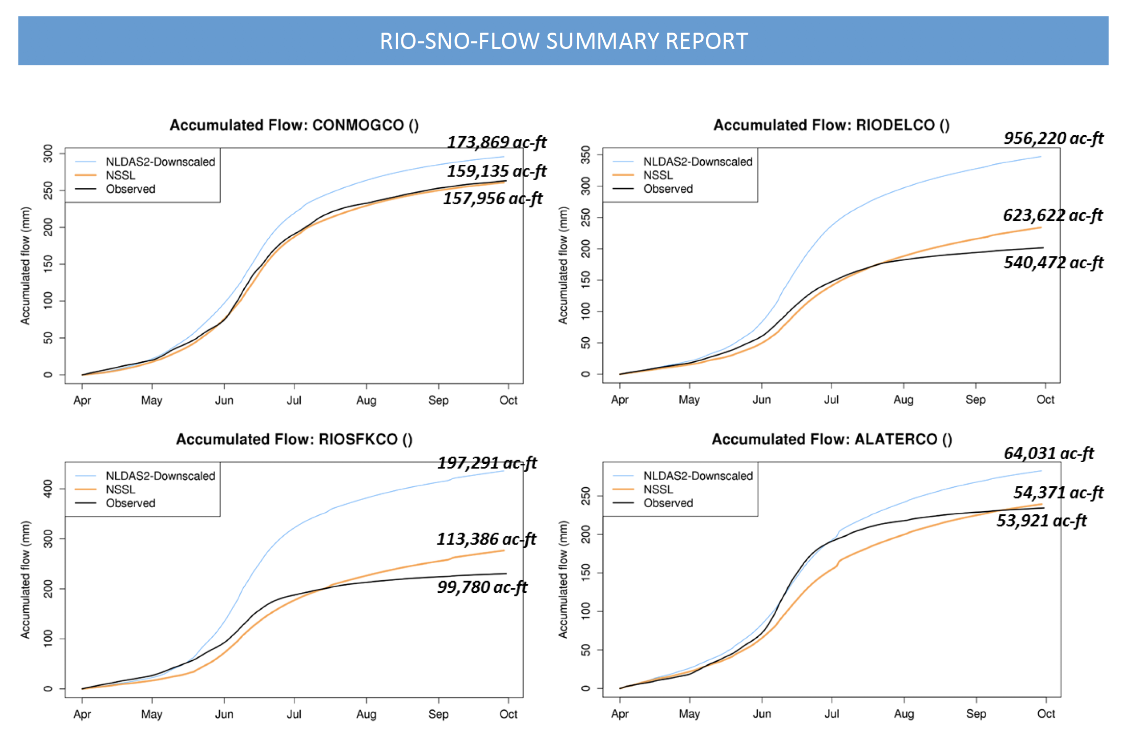
In January, 2016 the Colorado Water Conservation Board, in partnership with the National Center for Atmospheric Research (NCAR), NASA and other technical partners, published a study that indicated that by using portable weather radars to fill the gap in existing permanent weather radars coupled with better stream flow forecasting software from NCAR, significant improvements in forecasting stream flows generated year round by winter snow pack could be achieved, see fig. 36 below.
As encouraging as it was, this January, 2016 Report dealt only with the Upper Rio Grande River Basin in Southwest Colorado and for only one single year, thus referred to as a “Single Year – Single Basin” effort.
Our First Project will be a “Multi-Year Multi-Basin” effort. This project will be a 5-year effort to include:
We currently have the funding for our first radar to be installed along the Colorado River.
This Project is designed to: (a) duplicate and verify the findings of the original Single-Year Single-Basin study; as well as, (b) produce the Next Generation Stream Flow Forecasting Software Tool to enhance the accuracy in forecasting of stream flows critical to Western Colorado and it’s downstream users.
Excerpt from the January 2016 report:

Figure 36, on page 49 of the January 2016 Report is a collection of graphs depicting data from 4 separate existing measuring points along the Upper Rio Grande River, measuring accumulative stream flows in Acre Feet. The Light Blue Line depicts Forecasted Stream Flows using existing methods. The Orange Line depicts Forecasted Stream Flows using the data from temporary radar and improved NCAR Software. The Black Line depicts that Actual Measured Stream Flows. It is clear that using the radar and NCAR Model produced better forecasts.
Meteorologists criticize the delayed report as missing important details, discounting potentially damaging weather.
The Washington Post
The vast radar network across the United States is of the highest quality in the world, yet still has limitations.
Forbes
Congress doesn’t pay much attention to the weather unless there’s discussion about a disaster or climate change.
DAMWeather